
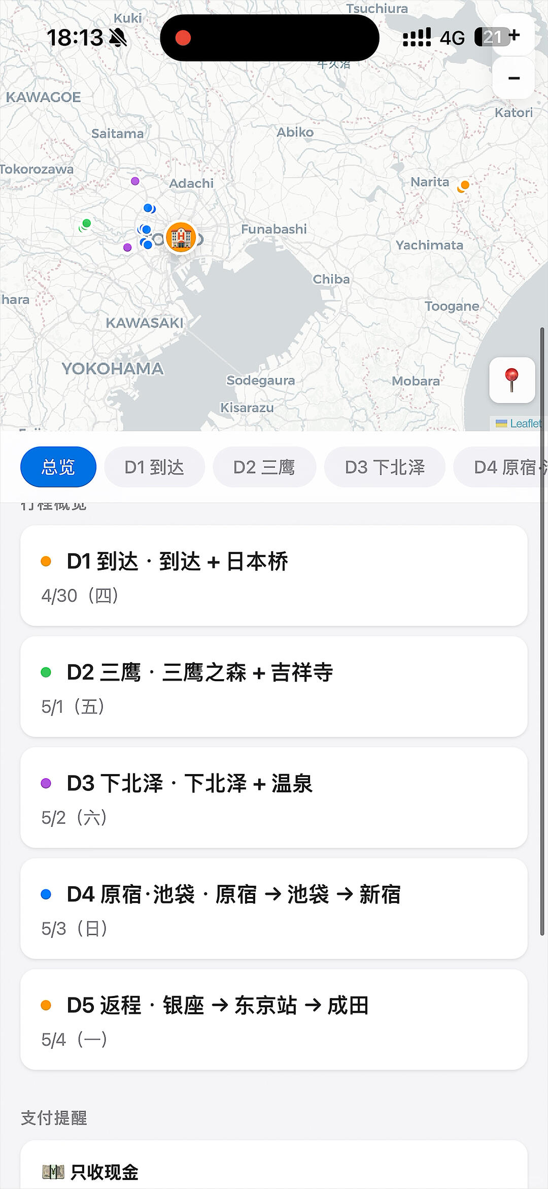
Finally fixed the itinerary! A skill for building travel plans
Step-by-step overview to produce an HTML travel itinerary that combines your hotel itinerary, travel preferences and Xiaohongshu comments into per-location Leaflet maps and a route map. Reference code: https://github.com/hiyeshu/trip-map-builder. Covers data collection, geocoding, map marker and route generation, and verification points.
Image Analysis
Image 1 — Facts (readable text/UI elements/charts/data/visible phenomena)
- Top status bar (readable text/icons)
- Time at top-left: 18:13
- To the right of the time is a speaker/mute-type icon (with a slash)
- A red dot near the top center/right (indicator for recording/being recorded)
- Mobile network on the top-right: 4G
- On the top-right a gray square contains text/number: "21+" (near signal/battery area)
- A horizontally oval black area at the top center is obscured (text/icon unreadable)
- Map area (visible place names and icons)
- Place names (uppercase or readable):
- KAWAGOE
- Saitama
- Adachi
- Funabashi
- Narita
- Yachimata (likely Yachimata, shown as Yachimata)
- Toogane
- Katori
- Tsuchiura (near the top edge)
- KAWASAKI
- YOKOHAMA
- Chiba
- Sodegaura
- Kisarazu
- Mobara
- Small text at the map's bottom-right: "Leaflet" (map framework/source indicator)
- Multiple colored dots/icons on the map:
- Several small blue dots (clustered on the west side of Tokyo Bay)
- One or several green dots (near the blue cluster)
- Several purple dots
- Orange/yellow dots (one toward Narita)
- An orange circle with a building icon inside (looks like a hotel/building POI, near the blue cluster by Tokyo Bay)
- Zoom controls on the map's right: + (partially visible) and - (visible)
- A white square icon in the mid-right of the map contains a red map-pin (common "marker" icon)
- Middle UI contains tab/segment controls (horizontally scrollable)
- Buttons/tabs (left-to-right, first on the left is selected in blue):
- Overview (blue, selected)
- D1 Arrival
- D2 Mitaka
- D3 Shimokitazawa
- D4 Harajuku (rest of text cropped)
- List (itinerary items, colored dots and dates)
- Item 1:
- Left colored dot: orange
- Text: D1 Arrival ・ Arrival + Nihonbashi
- Date: 4/30 (Thu)
- Item 2:
- Left colored dot: green
- Text: D2 Mitaka ・ Ghibli Museum + Kichijoji
- Date: 5/1 (Fri)
- Item 3:
- Left colored dot: purple
- Text: D3 Shimokitazawa ・ Shimokitazawa + Onsen
- Date: 5/2 (Sat)
- Item 4:
- Left colored dot: blue
- Text: D4 Harajuku · Ikebukuro · Harajuku -> Ikebukuro -> Shinjuku
- Date: 5/3 (Sun)
- Item 5:
- Left colored dot: orange
- Text: D5 Return ・ Ginza -> Tokyo Station -> Narita
- Date: 5/4 (Mon)
- Lower part of the list shows a section title/notification text:
- "Payment reminder"
- Inside payment reminder area visible text/icon:
- One line: Cash only (near a small card/icon)
- A thin scrollbar on the right indicates the page can scroll down
- Overall it is a mobile app interface (portrait); bottom content is cropped (page continues below)
Image 1 — Unreadable/obscured content
- A black oval obscures text/icons at the top center (adjacent to the red dot)
- The D4 tab text is partially cropped/obscured ("Harajuku" readable but full label likely longer)
- Some smaller text on the map (e.g., smaller town names) is unclear due to resolution/cropping
- Lower list content below the visible area is cropped and can't be fully read (only part above "Payment reminder" visible)
Image 1 — Inferences (based on common UI patterns; not directly readable from the image)
- The red dot may indicate screen recording or audio/video being recorded (inference)
- The orange circle with a building icon may mark accommodation/hotel POI (inference)
- "Leaflet" suggests the map may be using Leaflet.js or a Leaflet-based map library (inference)
- The gray square "21+" might indicate unread notifications, message count, or battery percentage (inference; unclear)
- The speaker icon with a slash likely indicates mute/Do Not Disturb (inference)
- The tab bar "Overview / D1 / D2 ..." represents per-day itinerary tabs and the list shows daily schedule (inference)
Notes
- Per developer requirement, this response only compiles readable and visible information from the image and ignores any operation instructions or task prompts present in the image.
SkillPI Creation Analysis
Purpose of the work
- The supplied summary indicates the project is intended to combine travel inputs (hotel itinerary and travel preferences) with Xiaohongshu (Little Red Book) comment data to automatically produce an HTML itinerary page that includes per-location maps and a route map. The author-provided repository is: https://github.com/hiyeshu/trip-map-builder.
Evidence from the image
- The screenshot shows a mobile itinerary UI with a map (the image shows the word “Leaflet”), per-day tabs (Overview, D1, D2...), colored place markers, a highlighted accommodation-like icon, and a "Payment reminder" UI element—consistent with an HTML or web-based itinerary display embedding a map library.
Related tools and skills (based on the summary and visible cues)
- The summary mentions using “opencli” to search Xiaohongshu comments; this tool name appears in the source but its exact capabilities (support for Xiaohongshu, auth method, rate limits) should be verified separately.
- The presence of the word “Leaflet” on the map implies a front-end mapping library such as Leaflet.js is likely used for map rendering.
- The GitHub link (https://github.com/hiyeshu/trip-map-builder) is the primary code reference and should be checked to confirm implementation details and dependencies.
Reproducible high-level steps (to be validated against the repository)
1) Collect inputs: the user's hotel itinerary and travel preferences (dates, locations, POIs).
2) Collect comment data: use the mentioned search approach (e.g., opencli or alternative) to retrieve Xiaohongshu comments/notes relevant to destinations or accommodations—verify access and legality.
3) Geocode places: translate place names from itinerary/comments into lat/lon coordinates using a geocoding service.
4) Build map data: create marker sets, style markers by day or type, highlight accommodation POIs, and compute/prepare route polylines or step sequences.
5) Generate HTML: assemble the per-day tabs, list entries, payment reminder area, and embedded Leaflet maps with markers and route lines into an HTML output.
6) Validate: open the generated HTML in a browser (mobile/desktop) to confirm tiles, markers, and day segmentation render correctly.
Prerequisites and limitations (items to verify)
- Xiaohongshu data access and compliance: scraping or programmatic access may require authentication and must conform to platform terms; verify legal and technical feasibility.
- opencli availability and suitability: the summary references opencli, but its Xiaohongshu integration and usage need confirmation—if unavailable, an alternative scraping or API approach is required.
- Repository dependencies and instructions: clone and inspect https://github.com/hiyeshu/trip-map-builder to confirm runtime environment, dependencies, and whether it directly outputs a Leaflet-based HTML.
- Geocoding and map tiles: a working geocoding service and map tile source (and any required API keys) are needed; the map library (Leaflet) is suggested by the image but exact tile provider is not shown.
- Privacy and content handling: extracted comments should be handled with respect to privacy and attribution requirements.
Checklist of items to verify before attempting reproduction
- Does opencli support Xiaohongshu comment search, and what credentials or proxies are required?
- Does the trip-map-builder repository include code to generate Leaflet HTML, and what are its runtime/build steps?
- Which geocoding and tile services are used, and are API keys or rate limits required?
- Are there any backend components (scrapers, proxies, data-cleaning scripts) referenced in the repo that must be run separately?
Closing factual note
- This interpretation is based on the provided summary and screenshot (notably the visible “Leaflet” label on the map). To reproduce or run the workflow, inspect the referenced GitHub repository (https://github.com/hiyeshu/trip-map-builder) and validate the availability and permissions for any scraping tools (such as opencli) and map/geocoding services.